General
National Id
France_11
Summary
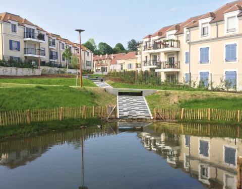
The city of Fourqueux (4000 inhabitants) has redesigned its urban space to build social housing. A plot of land has been set up at the heart of this area to collect and manage rainwater from the requalified area. Called water garden, the park collects water from 1.7 hectares of permeable and impervious area to allow it to infiltrate through a succession of temporary basins and a permanent one. It thus avoids the direct discharge of this rainwater into the separative network connected to the Seine. The water garden also acts as a natural space in the heart of a residential area, and allows the history of the municipality to be highlighted through cultural activities and the permanent display of old agricultural machinery.
Reviewed by
Fribourg-blanc
Light or indepth?
In-depth
The in-depth description of the case study
Location description
The commune of Fourqueux is located in the Yvelines, and has 4000 inhabitants.
In 2014, the center of the municipality of Fourqueux underwent an urban redevelopment operation, consisting of the creation of 80 housing units and the renovation and restructuring of the municipal social and cultural center. In addition, this work has led to the establishment of separate networks.
The area under requalification covers 1.7 hectares. In the center of this area was a private garden of 3200 m² dating from the 1930s, abandoned and left fallow. It was acquired by the city with the objective of making it a local park. Stormwater management was initially planned through underground networks in the road network, before the construction of the water garden in the park was considered.
The private garden was fallow, with natural biodiversity and no direct pressure. The subsoil of the area consists of very low-permeability green clays, which leads to the presence of several springs on the site.
NUTS Code
Île de France
RBD code
FRH-La Seine et les cours d'eau côtiers normands
Transboundary
0
NWRM(s) implemented in the case study
Longitude
2.064136
Latitude
48.887901
Site information
Climate zone
cool temperate moist
Monitoring maintenance
Monitoring requirements
No monitoring requirements.
Performance
Biophysical impact assessement method
No assessment methods or practices was used for assessing the biophysical impacts.
Design & implementations
Project scale
Small
Application scale
City
Installation date
2013
Age
6
Area (ha)
0.31 ha
Design capacity description
The park is able to manage 8 mm of rain
Factors constraints
8% slope
Favourable preconditions
To be consistent with the city's desire to share urban space with natural spaces, it was necessary to integrate a hydraulic and ecological dimension into the urban space, in particular by managing rainwater over an area of 3 ha. The choice of these types of developments was important so that the artificialization of the area by housing was not associated with soil sealing (and therefore runoff and stormwater management by the sewerage network).
Design contractual arrangement
| Arrangement type | Responsibility | Role | Comments | Name |
|---|
Design consultation activity
| Activity stage | Key issues | Name | Comments |
|---|
Design land use change
| Land use change type |
|---|
Design authority
| Authority type | Role | Responsibility | Name | Comments |
|---|---|---|---|---|
Lessons, risks, implications...
Success factor(s)
| Success factor type | Success factor role | Comments |
|---|---|---|
|
Attitude of decision makers
|
main factor
|
Financing
| Financing type | Comments |
|---|
Driver
| Driver type | Driver role | Comments |
|---|
Financing share
| Financing share type | Share | Comments |
|---|
Policy, general governance and design targets
Policy description
The objectives of the project are:
Manage 1.7 hectares of rainwater in the open air;
Create a local square;
Improvement of the living environment (thermoregulation, cultural site);
Participation in integrated water resources management.
Manage 1.7 hectares of rainwater in the open air;
Create a local square;
Improvement of the living environment (thermoregulation, cultural site);
Participation in integrated water resources management.
Policy target
| Target purpose |
|---|
Policy pressure
| Pressure directive | Relevant pressure |
|---|
Policy area
| Policy area type | Policy area focus | Name | Comments |
|---|
Policy impact
| Impact directive | Relevant impact |
|---|
Policy wider plan
| Wider plan type | Wider plan focus | Name | Comments |
|---|
Policy requirement directive
| Requirement directive | Specification |
|---|
Biophysical impacts
Information on retained water
The current rains are infiltrated, the heavier rains are partly infiltrated, the overflow joining the Seine.
Photo gallery

The slope of the site represented a technical difficulty because it was not suitable for rainwater infiltration. The solution proposed by the project manager was the use of a system of successive basins in "Asian terraces" format.