Swales are broad, shallow, linear vegetated channels which can store or convey surface water (reducing runoff rates and volumes) and remove pollutants. They can be used as conveyance features to pass the runoff to the next stage of the SuDS treatment train and can be designed to promote infiltration where soil and groundwater conditions allow. Three kinds of swale give different surface water management capabilities:
- Standard conveyance swale – Generally used to convey runoff from the drainage catchment to another stage of a SuDS train. They may be lined or un-lined, depending on the suitability for infiltration.
- Enhanced dry swale – Includes an underdrain filter bed of soil beneath the vegetated conveyance channel to accommodate extra treatment and conveyance capacity above that of the standard swale. The underdrain leaves the main channel dry except for larger runoff events, and will prevent channels becoming waterlogged where the swale is situated on gentler slopes. A lining can also be incorporated into the underdrain if infiltration to underlying ground is not appropriate.
- Wet swale - Where prolonged treatment processes are required for the storm runoff, the swale’s conveyance channel can be encouraged to maintain marshy conditions by using liners to control infiltration, or by siting in an area with high water table.
The promotion of settling is enhanced by the use of dense vegetation, usually grass, which promotes low flow velocities to trap particulate pollutants. In addition, check dams or berms can be installed across the swale channel to promote settling and infiltration. As a result, swales are effective in improving water quality of runoff, by removing sediment and particulate pollutants. In wet swales, the effectiveness is further enhanced by providing permanent wetland conditions on the base of the swale.
Swales are applicable to a wide range of situations. They are typically located next to roads, where they replace conventional gullies and drainage pipe systems, but examples can also be seen of swales being located in landscaped areas, adjacent to car parks, alongside fields, and in other open spaces. They are ideal for use as drainage systems on industrial sites because any pollution that occurs is visible and can be dealt with before it causes damage to the receiving watercourse.
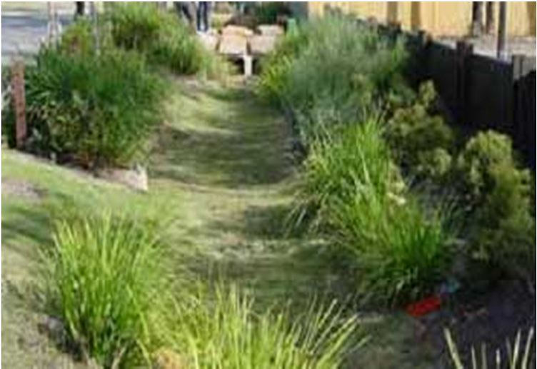
Swale
Source: Andras Kis’ presentation, NWRM Workshop 1
| Benefits | Level |
|---|---|
|
ES1 - Water storage
|
Low
|
|
ES3 - Natural biomass production
|
Low
|
|
ES4 - Biodiversity preservation
|
Medium
|
|
ES5 - Climate change adaptation and mitigation
|
Medium
|
|
ES6 - Groundwater/aquifer recharge
|
Medium
|
|
ES7 - Flood risk reduction
|
Medium
|
|
ES8 - Erosion/sediment control
|
Low
|
|
ES9 - Filtration of pollutants
|
Medium
|
|
ES11 - Aesthetic/cultural value
|
Medium
|
|
PO2 - Improving status of physico-chemical quality elements
|
Low
|
|
PO4 - Improving chemical status and priority substances
|
Low
|
|
PO5 - Improving quantitative status
|
Low
|
|
PO7 - Prevent surface water status deterioration
|
Medium
|
|
PO8 - Prevent groundwater status deterioration
|
Low
|
|
PO9 - Take adequate and co-ordinated measures to reduce flood risks
|
High
|
|
PO11 - Better protection for ecosystems and more use of Green Infrastructure
|
Medium
|
|
PO12 - More sustainable agriculture and forestry
|
Low
|
|
PO14 - Prevention of biodiversity loss
|
Medium
|
|
BP1 - Store runoff
|
Medium
|
|
BP2 - Slow runoff
|
High
|
|
BP5 - Increase evapotranspiration
|
Medium
|
|
BP6 - Increase infiltration and/or groundwater recharge
|
Medium
|
|
BP7 - Increase soil water retention
|
Low
|
|
BP8 - Reduce pollutant sources
|
Low
|
|
BP9 - Intercept pollution pathways
|
Medium
|
|
BP10 - Reduce erosion and/or sediment delivery
|
Medium
|
|
BP13 - Create riparian habitat
|
Low
|
|
BP14 - Create terrestrial habitats
|
Low
|
|
BP16 - Reduce peak temperature
|
Low
|
|
BP17 - Absorb and/or retain CO2
|
Low
|